Client: Mr A. O’Connell
Location: Ireland
Date: 2022
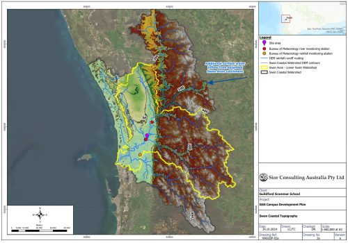
Mr. Anthony O’Connell approached Síor Consulting Ltd. (Síor) to conduct a Flood Risk Assessment (FRA) for a proposed residential development on a 0.5-hectare greenfield site in Knocksaharn, County Cork, Ireland. The site, located near a tributary of the River Sullane, is classified as being at medium risk of flooding according to the Office of Public Works (OPW) fluvial flood maps.
Flood risk assessments, particularly in the context of climate change, have become an integral part of planning applications in Ireland. The OPW’s Catchment Flood Risk Assessment and Management (CFRAM) maps, which predict flood extents during theoretical storm events, were key in informing the Flood Risk Assessment (FRA).
Síor was commissioned to provide comprehensive hydrological, hydrogeological, topographical surveying, and geospatial/IT consulting services with a site-specific approach to managing flood risk. The aim was to support the planning application by addressing the client’s needs while maintaining the technical integrity of the reporting and analysis.
Síor’s responsibilities included:
- Liaison with Cork County Council planning authorities to scope and coordinate appropriate works.
- Interpretation of flood risk modelling outputs to support informed decision-making within the Irish planning process framework.
- Procurement and facilitation of a topographic survey and aerial drone survey of the site.
- Creation of a site-specific digital elevation model (DEM) with 0.25m resolution.
- Engagement with relevant stakeholders, including governmental and non-governmental organisations.
- Flood risk modelling and analysis tailored to meet Irish planning process requirements and to provide an in-depth, site-specific approach for the river catchment section.
Síor applied our combined geoscientific expertise to:
- Developed a site-specific flood model and conducted detailed analysis, resulting in a planning design solution that met application requirements and enabled construction to commence.
- Designed a mitigation strategy to elevate the property above the floodplain by 1m, achieving a 0.6m clearance above the 1-in-100-year flood level, while maintaining the site’s floodplain storage capacity.
- Performed flood storage calculations using site-specific topographic data to offset floodplain conveyance loss by removing material within the site boundary, creating additional flood storage.
- Collaborated with Project Design Engineers, Architects, and Cork County Council planning authorities to facilitate planning approval.
- Delivered technical flood risk modelling and reporting tailored to the client, ensuring successful design and smooth transition to the construction phase. Identified potential site risks through interpretive reporting to guide future development activities.