
Python Geoscience Power
What is Python in Geoscience?
Python is a high-level scientific programming language renowned for its simplicity and readability. It has become the go-to choice for geoscientists due to its extensive third-party libraries, ease of use, and flexibility.
What makes it so powerful?
Python’s power in geoscience stems from its user-friendly design and robust capabilities. Its simplicity makes it accessible to both experts and newcomers, while its specialised libraries cater directly to the complex needs of geoscientific analysis.
How do we use it?
For Síor, Python has become a central part of our toolbox, enabling and scaling environments such as geoscientific modelling, geospatial processing, data engineering, and geospatial visualisation.
For the latter, it not only facilitates the creation of detailed maps and diagrams, but it also enhances our capacity to automate the required data processing and analysis tasks leading to visualisation. This approach can be applied to a wide variety of areas, including environmental risk assessments, hazard mapping, resource management, and climate risk profiling.
When it comes to automating the production of visual content, we leverage Python to access certain geospatial software APIs – either licensed (e.g., ESRI) or open source (e.g., WhiteboxTools) to build systems that are customised to our Client’s needs and can be and robustly deployed.
Amongst other use cases, we employ this approach to automate the production of geoscientific drawings, including maps, process diagrams, hydrographs, sub-surface cross-sections, and borehole logs.
Python’s Role in Síor’s Geoscience Applications:
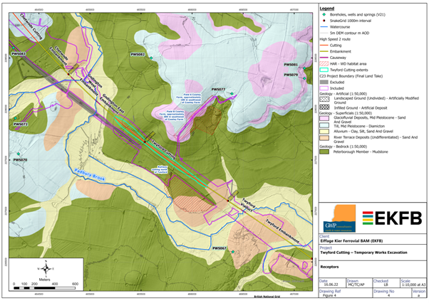
As part of our technical work, Síor is responsible for creating and managing maps serving diverse objectives such as environmental risk assessments, resource management, climate change analysis, natural disaster preparedness, field work and surveys. Drawings’ departments typically spend significant time manually creating and updating maps.
Síor has instead developed bespoke tools, leveraging Python, that automate the production of drawings, streamlining the mapping process and enhancing efficiency for our drawings’ department.
User interaction typically involves the following process:
- Input: user-specified parameters, such as the map extent, content to be included (e.g., specific layers required), auxiliary information, as well as map layout preferences for an entire set of maps, are provided to the tool through a user-friendly interface.
- Processing: the tool interprets user-specified parameters, fetches the required data from the respective sources, performs necessary geoprocessing tasks, generates the various drawings, and exports them in the requested format.
- Output: the tool is capable of producing high-quality, custom, and detailed maps in various formats (e.g., PDF, image files, etc.) with the requested content, ready for use and easily revised.
Benefits:
Time Efficiency: significantly reduces the time required to generate maps, allowing us to provide timely information to stakeholders.
Consistency: ensures consistency in map presentation and content, eliminating discrepancies that might arise from manual map production.
Streamlined Updates: enables swift updates as new data becomes available, ensuring that maps always reflect the most current information.
The development of these tools, which leverage Python to automate the production of visual content significantly streamlines the processes for geologists and GIS analysts. It not only expedites the generation of these drawing products but also enhances the accuracy and depth of analysis, ultimately aiding in better-informed decision-making and reporting, whilst also allowing for easy app online publication.
Comments (0)