
Now, it’s time to get a little more personal. If you have been following this…
A Multidisciplinary Approach Part 2: ArcGIS Collectors App and Field Application
As a community of environmental, GIS, and computing professionals, all of us at Síor Consulting have been exposed to very different professional environments, challenges and also computer systems – software and hardware – throughout our careers in our respective fields. We try to leverage the full breadth of experience within our team, striving to deliver tailored, precise, and efficient solutions for both desk- and field-based environmental projects. To this end, we develop and deploy a wide range of tools, based on geographic information systems (GIS).
The ArcGIS Collectors Mobile App is a key tool in our pursuit of precision and efficiency. It allows us to capture and return accurate geospatial field data that integrates seamlessly into ArcGIS Pro, our central desktop environment.
Workers in the field capture geospatial data while desk-based team members can access, visualise, and assess it as it is gathered, in real time. With advancements in GPS technology, smartphones are now reliable geolocation devices, with an accuracy often better than +/- 3 meters, and this will continue to improve each year.
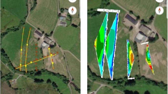
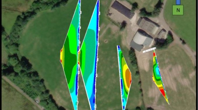
A recent project undertaken by Síor made use of the Collectors App for deployment of geophysical surveying and for client engagement. This project aimed to identify a suitable location to site an agricultural groundwater abstraction well, and it was undertaken in collaboration with Southern Pumps Ltd.

Prior to getting into the field, an ArcGIS Pro environment was created in the office. This environment was subsequently uploaded to our ArcGIS Online portal, allowing fieldworkers to access the environment via the Collectors App. Fieldworkers could then capture geospatial data, such as field observations, geophysical surveying locations, and more, in the field.
Recognising the importance of stakeholder communication, Síor coordinated closely with both the client and the drilling contractor to ensure the chosen location was not only suitable with regards to water quality and yield, but also accessible by the driller and proximal to a sufficient power source.
At Síor, we believe the Collectors App is a crucial tool when it comes to client and stakeholder engagement, as it acts as a visual aid that allows us to guide clients through project decisions, such as choosing a specific location for a groundwater well.
I hope you enjoyed this blog on the Collectors App. If so, stay tuned for the next blog in this series, where I will talk about geophysical surveying, specifically Electrical Resistivity Tomography (ERT) surveying, and its use in the siting of a commercial groundwater abstraction well for a dairy farm.
Related Posts
Comments (0)